
by DR EMAL RUMI
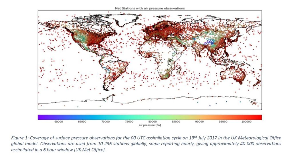
The prediction of weather and understanding of climate change, on timescales ranging from hours to centuries, remains key challenges for society. In a warming climate, the intensity and frequency of devastating weather events are increasing, with more casualties and greater infrastructure damage. In line with ESA’s Earth Observation Science Strategy, the BARODAR mission has the potential to provide an unprecedented 10 km spatial resolution for global surface air pressure measurements, at high accuracy and temporal resolution, for the first time from space. Surface air pressure is one of the most important parameter in Numerical Weather Prediction (NWP) and climate models. Currently only ground based measurements of surface pressure are available from weather monitoring stations. These cover less than 30% of Earth’s surface and are supplemented over the oceans by reports from ships, buoys. The coverage of the land-based network is highly inhomogeneous, with relatively dense coverage over Europe and North America but sparse coverage over Africa, South America, large regions of Asia, and Antarctica. The coverage over oceans is, by contrast, extremely sparse in relation to the typical spatial scales of synoptic weather systems. The high latitudes ocean areas in both northern and southern hemispheres are particularly sparsely sampled. Three areas that stand out as particularly problematic: the Southern Ocean, the Arctic and the Antarctic continent. The fact that weather forecasting is less successful in these three particular areas, as measured with many different metrics, is partly attributed to the lack of surface air- pressure observations. The only way to provide global coverage is by satellite remote sensing. Thus, there exists a clear requirement for a global surface pressure measurement capability. Figure 1 shows an example of the distribution of in-situ reports available for initiation of NWP models. Global surface pressure measurements from space will improve the forecast power of NWP dramatically, saving lives and mitigating the effects of natural disasters. BARODAR mission data applications include Numerical Weather Prediction models (NWP), climate, atmospheric composition, gravity, ocean dynamics and sea level monitoring.
Accurate global-scale measurement of surface pressure presents a substantial technical challenge, which can only be achieved by remote sensing from space. Retrieval of atmospheric pressure from satellite observations requires very accurate knowledge of the atmospheric mixing ratio of the spectral feature to be targeted. In practice, molecular oxygen offers the only viable candidate, since its mixing ratio is effectively constant over the full range of atmospheric conditions and altitude. The BARODAR method relies on the frequency dependent absorption of mm-wave radar pulses in the upper wing of the 60 GHz oxygen band. The ratio of transmittance of two channels, i.e the differential absorption, is a measure of the total oxygen in the path. Since the oxygen is well-mixed in the atmosphere, this ratio is related to the total surface pressure. Adding a third channel will produce another ratio which will reduce uncertainty. These measurements do not themselves suffice, however, because they are also sensitive to the atmospheric temperature profile, water vapour content and cloud cover. The novel design of the BARODAR instrument is based on three measurements at separate frequencies, characterising the atmosphere both inside and outside of the oxygen absorption band. This pulsed radar operates in two modes: the first mode measures signal returns from the surface at three different frequencies for surface pressure retrieval. The second mode transmits longer pulses in the out of band channel to measure cloud returns. This enables cloud detection, necessary to improve the accuracy of pressure measurements. The BARODAR instrument will fly with a multi-frequency microwave radiometer to sense water vapour, liquid water, and temperature profiles. This atmospheric correction information is required to accurately derive surface pressure and to provide great value due to the co-location in time and space with surface pressure measurements. Future user requirements for accuracy, spatial resolution, and temporal availability of the measurements for different applications were identified, and led to the following BARODAR Mission Objectives:
1- Provide regular, accurate, consistent and at global scale measurements of surface pressure with strong emphasis on oceans and polar regions, for the first time from space. It will deliver unprecedented 10 km spatial resolution with an uncertainty of (1-2 hPa), and on regular basis. (BARODAR flagship product).
2- Global temperature profiles, integrated water vapour and liquid water profiles direct measurements co-located in time and space with pressure measurements. (BARODAR auxiliary products).
3- Ice Water Content (IWC), snowfall, and light precipitation data, (BARODAR cloud and precipitation products).
The advances in surface pressure observational capabilities are expected to address the following Scientific Objectives [SO], with immediate applications and societal benefits.
[SO1] BARODAR mission objective is to improve the quality of Numerical Weather Prediction (NWP) models through improved initial state and thereby their predictions by providing global, consistent, and regular near real time observations of surface pressure. Dramatically improve the prediction accuracy of the lead time, path, and intensity of extreme events, including the prediction of the center of storms and tropical cyclones to save lives.
[SO2] BARODAR Better climate monitoring by establishing the start of global records of surface pressure observations. This requires surface pressure observations that are global, continuous, consistence and from the same instrument. Other meteorological variables are currently available from
satellites observation, apart from the most important variable, surface pressure, and that is a big gap which BARODAR will fill.
[SO3] BARODAR Better understanding of ocean dynamics and sea state. To provide observations of surface pressure over the oceans and seas which are currently almost not existing. This will dramatically improve sea height measurements and therefore storm surges predictions. It will improve dry tropospheric and dynamic atmospheric corrections, and therefore improves accuracy provided by other missions such as altimeters.
BARODAR mission will operate on a sun-synchronous (SSO) Dawn-Dusk orbit at 493 km, conducting nadir looking observations with two instruments. First instrument is the Differential Absorption Radar (DAR) payload instrument to measure attenuation caused by oxygen absorption at three channels (65.5, 65,9, 78.2 GHz). This is an active sounding conventional radar operated using one 2 m diameter antenna for transmitting and receiving. The second instrument is the Microwave Radiometer (MWR) to provide wet tropospheric correction for the radar measurements and based on S3NG design and using 0.8m diameter antenna. Satellite platform is based on Astrobus Neo avionic (LSTM like), with adaptation for a SSO dawn-dusk orbit. Data products from BARODAR produced with corrections independently of any other instrument or other mission data. Data downloads during each orbit will be available at regular temporal resolution to be assimilated into the NWP models. BARODAR will be launched in 2036 on a Vega- C launcher and will have a controlled re-entry in 2039.