
SEASTAR+: enhancing the mission concept
Fast Track – 10th Call (Completed 2019)
Lead Organisation: National Oceanography Centre partnered by Airbus DS Ltd & Satellite Oceanographic
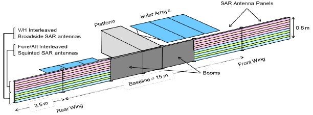
The objectives of the SEASTAR mission are to deliver high-resolution wide-swath synoptic maps of total ocean surface currents and winds from space to improve the parameterisations of oceanic sub-mesoscale dynamics and provide mapping of total ocean surface currents and winds in the coastal zone, shelf seas, the Marginal Ice Zones and oceanic areas of special interest.
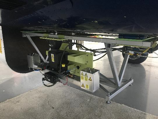
Ship Position and Detection Radar (SPIDER)
Flagship – 10th Call (Completed 2018)
Lead Organisation: Airbus DS
The work undertaken includes the implementation, validation, and verification of a SPIDER airborne proof-of-concept demonstrator from an existing preliminary design based on COTS components. The technology for the demonstration implements a compact lightweight design that can be adapted to an existing aircraft pod making the approach cost-efficient.
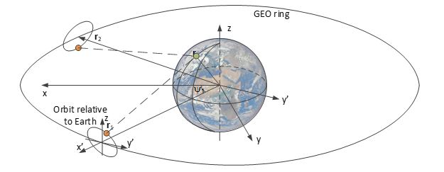
Feasibility of Passive Bistatic Geosynchronous Radar using Comsats
Pathfinder – 10th Call (Completed 2018)
Lead Organisation: Cranfield University partnered by University of Birmingham
This study evaluated the feasibility of carrying out passive bistatic geosynchronous radar imaging using comsat transmissions. In this configuration, the transmitter and receiver are both in geosynchronous orbit with inclination and eccentricity small enough to stay near their allocated position but large enough to create a useful synthetic aperture.
Next Generation Radar Electronics
Flagship – 8th Call (Completed 2018)
Lead Organisation: Airbus DS
The proposed work is intended to develop existing Radar Electronics products, developed by Airbus Defence and Space in Portsmouth, to enable them to support a broader range of future missions than currently possible.
The research and critical developments to be undertaken will include the evolution and demonstration of hardware modules applicable to the ICE and NIA products. The requirements of the BIOMASS and SAOCOM-CS missions (to the extent that they are currently known) will be used to guide the bread-boarding and demonstration activities.
Using SAR to observe Earth Surface Deformation in Three Dimensions
Pathfinder
Lead Organisation: University of Leeds partnered by Astrium Satellites Ltd.
Earth surface deformation is the primary signature of a wide range of geophysical processes. The SuperSAR mission uses a space based radar instrument to provide data that can be processed to give interferograms of the Earth from 4 distinct viewing geometries, enabling SuperSAR to make measurements of Earth surface motion in three dimensions. The primary scientific objective of SuperSAR is to measure Earth surface deformation to a sufficient precision to improve our capacity to predict the likelihood of hazardous events, to assess the stability of geological formations for the processing of geo-resources, and to assess the stability of Earth’s ice sheets.
Emulation and Performance Study of an On-Board Level 1 Processor for Squinted SAR
Pathfinder
Lead Organisation: Airbus DS
This project continues work from a previous phase project on on-board processing for SAR.
System and Applications Study for a Future Geosynchronous Radar Mission
Pathfinder
Lead Organisation: Cranfield University partnered by University of Birmingham
GEO is already used by weather satellites to take visible images using the Sun’s illumination. Weather satellites produce frequent images over wide areas, but GEO has not been used so far for radar. Calculations and some initial experiments show that radar imaging from GEO is possible. This project’s aims are to resolve some of the remaining technical problems, especially the processing needed to form good images, and to evaluate potential applications for GEO radar.