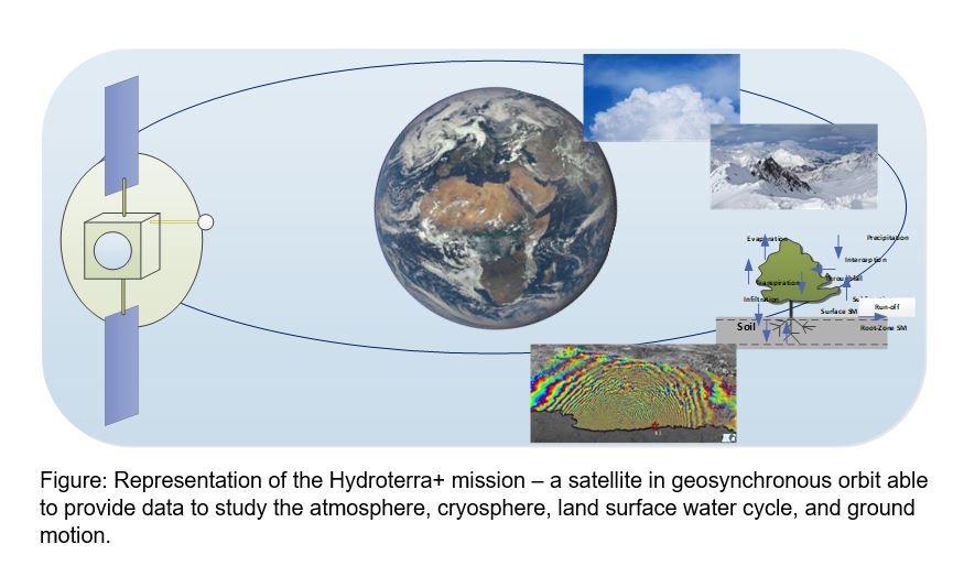
Hydroterra+ is a proposed mission for the European Space Agency’s 12th Earth Explorer opportunity. Its goal is to help understand rapid processes of the water cycle, such as extreme weather events and the daily use of water in agriculture. It would also create an opportunity for much improved observations of ground motion, with applications for landslide monitoring and improved understanding of earthquakes, volcanoes, and tectonic motion.
Hydroterra+ is a development of the Hydroterra mission proposed for the 10th Earth Explorer (EE10). Hydroterra was reviewed in December 2020 and commended for its innovations in science and technology, but at that time was not ready for selection for flight. Hydroterra+ builds on the learning from Hydroterra and adds new scientific expertise. Since 2020, the science team has continued to work on the mission concept and on the scientific motivation. With the EE12 opportunity, this project’s focus is on consolidating aspects of the Hydroterra+ science case and implementation concept to address weaknesses and exploit recent developments. In particular, there have been several recent field campaigns to mature the science case, and the mission team has been re-organised to focus on areas where Hydroterra / Hydroterra+ has important strengths.
Hydroterra+ proposes to use a radar in geosynchronous orbit to observe the water cycle. Radar is particularly sensitive to water, and the orbit, with a permanent view of Europe and Africa, provides the ability to observe an area several times a day, and thus for the first time from space to see processes on timescales of 10s of minutes to hours. This is expected to unlock important areas of Earth system science. A key by-product of the mission concept is the ability to see ground motion on these short timescales too. This also enables significant new science.
The study funded by the UK’s Centre for Earth Observation Instrumentation will focus on areas of the Hydroterra+ mission with particular UK interests. These are:
- Improved understanding of intense weather systems (mesoscale convective systems) – these systems are globally important, are becoming more important as Earth’s climate changes, and are especially active across Tropical Africa and around the Mediterranean,
- Exploiting the imaging versatility and temporal resolution for ground motion, with applications for tectonics, volcanoes, earthquakes and landslides,
- Continued validation of the mission concept for measuring geophysical parameters: we have demonstrated parts of the measurement process, but do not yet have a full simulator which can show how accurately we can measure parameters in realistic scenarios,
- Optimising the mission design through a better understanding of the cost and risk for different implementation options.
The project team members are the universities of Cranfield and Leeds, the UK Centre for Ecology and Hydrology, and Airbus Defence and Space Ltd. Each partner contributes significant relevant expertise to help develop a strong science case and mission concept for Hydroterra+.
A radar for Earth system science in geosynchronous orbit will be an unprecedented capability. It would become an Earth observatory which can be programmed for a wide range of scientific (and, eventually we hope, operational) uses. Its novel capability may also surprise us by unlocking new science areas.