
Lead Organisation: STFC RAL Space
Project Lead: Dave Smith
Partners: University of Leicester
There is a growing user demand for thermal infrared measurement at spatial resolutions <100m and spectral resolutions <50nm from satellite sensors. Current operational missions provide one or the other, but not both. ESA has recognised this need from several studies and for the Copernicus Space Component Evolution Plan (CSCEP) is now developing a proposed thermal infrared imager (LSTM) for land use applications. The current science and applications are restricted by limited spectral bands (8, 9, 10, 11, 12μm) and temporal sampling (1 day). Extending the spectral coverage and resolution will add more information for applications such as land surface temperature (LST), sea surface temperatures (SST) in coastal waters, land surface emissivity, land classification, soil composition, volcanology, fire radiative power, cloud masking, aerosols, and trace gases.
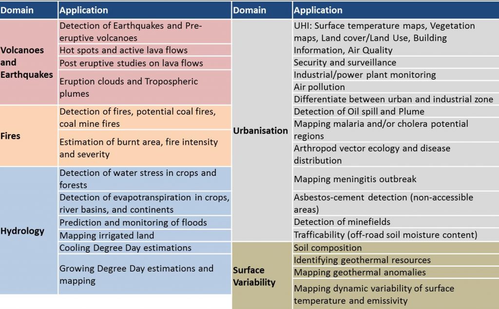
Existing TIR imaging instruments do not yet meet the future applications requirements. Current and proposed missions, such as LSTM, would only address 19 of these applications, whilst HHRTII would address 36 applications. The University of Leicester has analysed and summarised science-led applications that would benefit from a high spatial and spectral resolution thermal infrared imaging spectrometer.
There are many technical challenges to overcome to provide an instrument concept to meet the requirements, in particular the physical limits of detector technology. The list of technical specifications from the science drivers was used as a basis to evaluate the feasibility of an instrument design concept. By simulating the expected performance based on existing detector technology, the team explored the trade-off between spectral/spatial resolutions, input optics size, and platform altitude.
The analysis has identified two static imaging spectrometer designs with hyperspectral capability, that offer different benefits. The developed radiometric model demonstrated that using an MCT cooled detector on a LEO satellite would require an optical input diameter of ≥0.5m to achieve an NEdT of 0.2K with a spectral and ground resolutions of 50nm and 100m, respectively. Alternatively, if mounted on a HAPS platform at much lower altitude, the improvement in NEdT can be almost a factor of 100 for most spectral bands.
These instruments, perhaps in combination, can broadly address all of the user requirements shown in the Table above. Continuing the development activities would put the UK in a strong position to take these concepts forward into a mission compatible with smaller spacecraft/constellation and/or a HAPS. Such a mission could be a national mission, or with ESA as part of e.g. the Earth Explorer programme, or as a bilateral with a European or other international partner should such an opportunity arise. While currently at an early evaluation stage, the subsequent development of a mission would support national and international efforts to understand and mitigate climate change and natural hazards, both at the local and global scale.