Lead Organisation: NOC Southampton
Project Lead: Christine Gommenginger
Partners: Airbus Defence and Space Ltd, Satellite Oceanographic
The SEASTAR+ study project focused on further development and preparation of an Ocean Surface Current (OSC) mission as a candidate for the ESA Earth Explorer 10 call for missions.
The objectives of the SEASTAR mission are to deliver high-resolution wide-swath synoptic maps of total ocean surface currents and winds from space to improve the parameterisations of oceanic sub-mesoscale dynamics and provide mapping of total ocean surface currents and winds in the coastal zone, shelf seas, the Marginal Ice Zones and oceanic areas of special interest. The primary products would consist of total ocean surface current vectors, ocean wind vectors and directional ocean swell spectra with challenging requirements on spatial resolution (1 km or finer) and current retrieval accuracy (5 cm/s).
The SEASTAR+ project consisted of scientific and technical activities aimed at increasing both the Science Readiness Level and the Technical Readiness Level of the mission by reviewing trade-offs between the science objectives and the instrument concept, and enhancing the maturity of the technical solution. The output of this study provided critical input for the SEASTAR mission proposal submitted to EE10 in March 2018, which strengthened the credibility of the mission concept’s ability to achieve the defined measurement requirements and enable it to become a successful Earth Explorer 10 candidate.
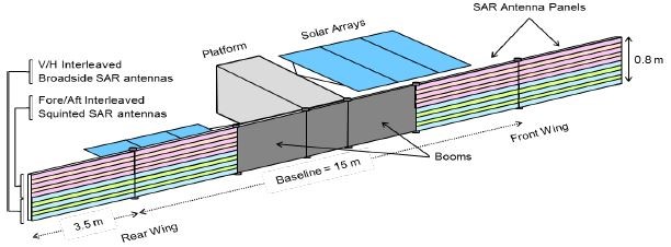
The SEASTAR mission proposal put forward an ATI-based concept with the following scientific objectives:
a) deliver two-dimensional maps of total ocean surface currents and wind vectors with unprecedented resolution and accuracy to support research in submesoscale ocean dynamics and air-sea interactions at scales down to 1km;
b) determine the magnitude and spatial and temporal characteristics of ocean submesoscale in the global coastal zone, the Arctic margins and ocean Sites of Special Scientific Interest;
c) support the validation of high- resolution ocean and atmospheric models and the development of improved parameterisations to represent the impact of submesoscale on circulation, air-sea interactions and vertical transports on basin to climate scales.
The mission consists of a single satellite carrying a single instrument payload based on an ATI-based solution with two squinted look-directions. The satellite uses a sun synchronous orbit (SSO) with fast-revisit orbital phases (1-2 day repeat) alternating with medium-revisit orbits (5-20 days repeat). While there is no dependence on data from other satellites, there are scientific benefits from synergy with Sentinel-1 and Sentinel-3.
The EE10 call came earlier than anticipated and there was a break in the Project between November 2017 and March 2018 while the mission proposal was prepared. In September 2018, the outcome of EE10 indicated that SEASTAR was not one of the three missions selected to proceed to Phase 0, despite excellent reviews. SEASTAR continues to be promoted for implementation through other avenues and opportunities within ESA, Europe and beyond.